OUTBACK TRACKS
 Winding along Thunderbolt’s Way
Thunderbolt’s Way offers a scenic route through the hilly heart of the New England tableland, which is a pleasant-paced, history-steeped alternative to the major highways traversing New South Wales.
Story Kirsty McKenzie Photos Ken Brass
Thunderbolt’s Way is variously described as the shortest route from Sydney to Brisbane, a pleasant detour from the traffic and trucks of the Pacific and New England highways or the gateway to the towns and regions of north-west New South Wales.
 Named for the bushranger Captain Thunderbolt (see accompanying story),
who worked a swathe of country from Taree, on the coast, to Tenterfield,
on the
New England tableland, during the 1860s, the route leaves the Pacific Highway
just north of Newcastle. It begins life as a road called the Bucketts Way
(from the Buccons, an Aboriginal word describing the mountainous rock formations
behind Gloucester) and travels past the World Heritage listed Barrington
Tops before rising in countless twists and turns up to the high country
of the New England region.
Named for the bushranger Captain Thunderbolt (see accompanying story),
who worked a swathe of country from Taree, on the coast, to Tenterfield,
on the
New England tableland, during the 1860s, the route leaves the Pacific Highway
just north of Newcastle. It begins life as a road called the Bucketts Way
(from the Buccons, an Aboriginal word describing the mountainous rock formations
behind Gloucester) and travels past the World Heritage listed Barrington
Tops before rising in countless twists and turns up to the high country
of the New England region.
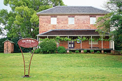
From the Pacific Highway it’s 35 kilometres to Stroud,
which Robert Dawson, the first agent of the Australian Agricultural Company
established in 1826
and named for a perceived resemblance to the Cotswolds in England. These
days Stroud is a pretty, hilly service town for the surrounding farming
community set in a kind of early 19th-century aspic with lots of historic
buildings
including an early AACo school, church and even a village green.![]()
Full story OUTBACK Issue 35 June/July 2004